Hurricane Melissa has grown into a fierce Category 4 storm, slowly churning through the Caribbean Sea as it aims directly at Jamaica and surrounding islands. The hurricane packs maximum winds of 145 mph and continues getting stronger, making it one of the most dangerous storms we’ve seen in recent years.
Melissa’s Current Location and Movement
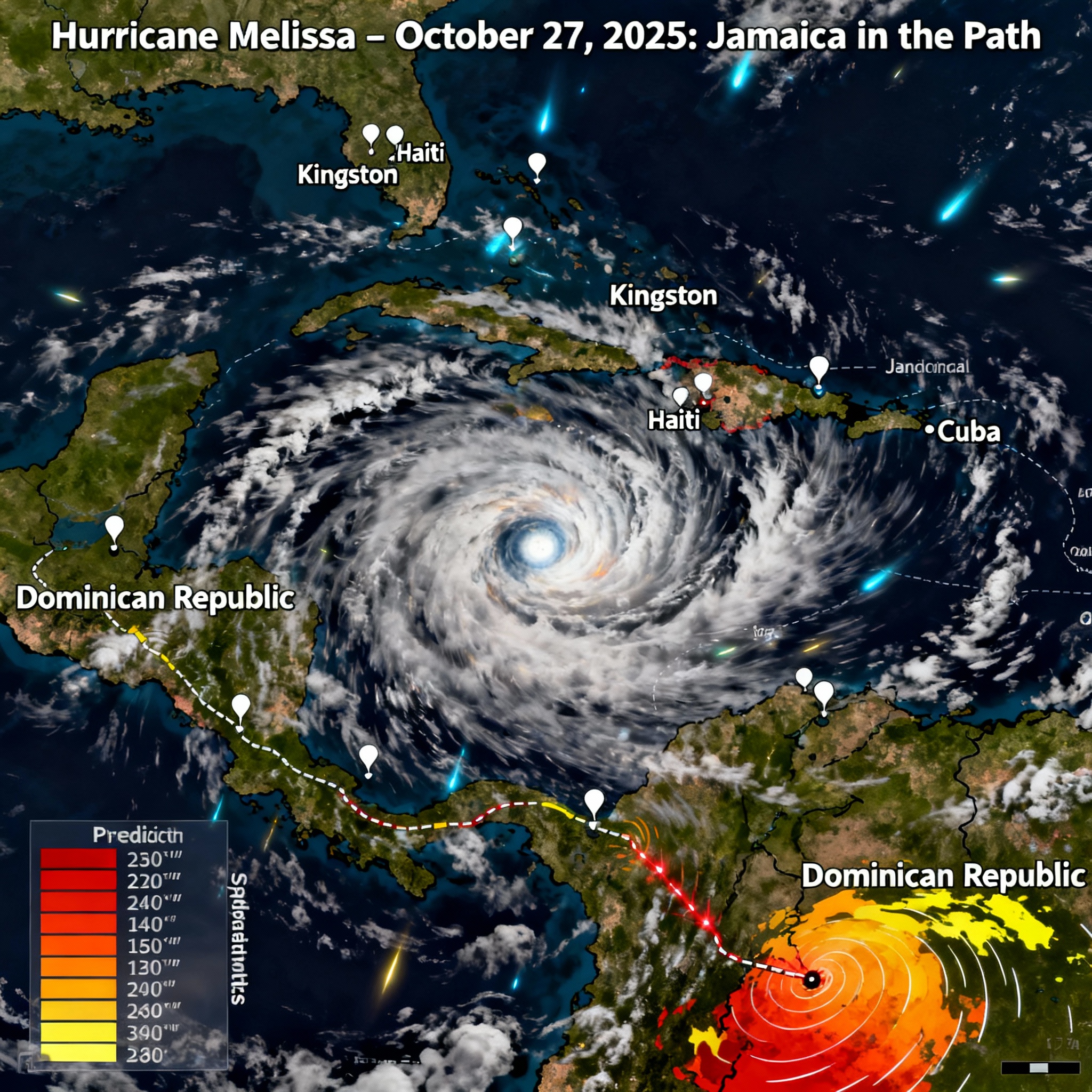
Weather experts at the National Hurricane Center and other agencies have been tracking Melissa’s every move. What started as a tropical storm quickly exploded into a Category 4 hurricane on October 26, 2025, as it crept northwest through the warm Caribbean waters. Right now, the storm sits about 110 miles south of Kingston, Jamaica’s capital city, crawling westward at just 3-5 mph—a scary slow pace that means more rain and flooding for areas in its path.
Weather forecasters expect the hurricane to slam into Jamaica late Monday or early Tuesday morning, bringing catastrophic winds, heavy downpours, and a deadly storm surge. Once Melissa finishes with Jamaica, it’s set to head toward southeastern Cuba and the Bahamas, keeping most of its destructive strength.
Jamaica’s Storm History and What Melissa Could Bring
Major hurricanes don’t hit Jamaica directly very often. The last Category 4 storm to strike the island was Hurricane Gilbert back in 1988, which packed 130 mph winds and forced one out of every five people from their homes. Weather experts are warning that Melissa might be even stronger than Gilbert, with winds possibly reaching 155 mph. If that happens, Melissa could become the most powerful hurricane to hit Jamaica in more than 35 years.
Along with the extreme wind damage, some parts of Jamaica and southern Haiti could see up to 40 inches of rain. That massive amount of water will likely create dangerous flash floods and cause deadly landslides across the mountainous terrain.
Key Storm Statistics and Predictions
Category: 4, possibly strengthening to Category 5
Peak Winds: 140-145 mph (gusts even higher)
Speed: Moving west at 3-5 mph (slow speed makes things worse)
Rainfall: 15-40 inches expected across Jamaica and Haiti
Storm Surge: 9-13 feet along Jamaica’s southern coastline
Areas at Risk: Jamaica, Haiti, Dominican Republic, Cuba, Bahamas
Weather Models and Storm Path
Computer weather models—nicknamed “spaghetti models” because their overlapping lines look like tangled pasta—mostly agree that Jamaica will take the worst hit. However, they show some differences about exactly where the storm will track inland and what happens next. All models highlight the storm’s slow crawl, which means longer periods of damaging conditions.
Getting Ready and Official Warnings
Jamaica’s government has issued hurricane warnings across the island and tropical storm watches, shutting down airports and telling people to find safe shelter. Officials expect widespread damage to roads, power lines, and buildings that could leave communities cut off for days. Local news shows massive evacuation efforts happening in flood-prone areas and coastal towns.
The National Hurricane Center keeps sending out updates every hour, emphasizing how life-threatening Melissa’s impact will be, especially from flooding and storm surge.
Effects Across the Region
Melissa isn’t just threatening Jamaica. Southern Haiti and parts of the Dominican Republic are already getting pounded by heavy rain and flooding from the storm’s outer edges. Officials in those areas report several deaths and thousands of people forced from their homes. The hurricane is expected to barrel through southeastern Cuba and then the southeastern Bahamas, putting a huge area at risk.
Climate Change and Rapidly Strengthening Storms
Melissa’s explosive strengthening—gaining more than 55 mph in wind speed within 24 hours—fits a growing pattern linked to global warming. Warmer ocean water gives hurricanes more energy, creating stronger and more frequent storms. The 2025 Atlantic hurricane season has already produced several rapidly intensifying hurricanes, showing why we need better climate action and storm preparation.
A Storm Jamaica Won’t Forget
Hurricane Melissa’s approach marks one of the most serious threats Jamaica has faced in decades. Its slow movement, combined with torrential rain and powerful winds, promises catastrophic flooding, landslides, and widespread destruction. The next few days will test how well the island and the region’s emergency systems can handle a storm that might change how the Caribbean prepares for hurricanes.
People living in the storm’s path need to stay alert, listen to official warnings, and take every safety step possible. We don’t know Melissa’s full impact yet, but early signs point to a historic storm that researchers and residents will remember for years to come.
This report combines the newest official information, weather model predictions, and local reports to give you a complete picture of Hurricane Melissa’s threat to Jamaica and the broader Caribbean region in 2025.
Additional hurricane tracking maps and satellite imagery could enhance this coverage for readers wanting more detailed information.

Saurabh Kumar is the founder of SaurabhOrbit.com, a hub for tech news, digital marketing insights, and expert blogging advice. With a deep passion for technology and digital strategies, Saurabh simplifies complex trends into actionable insights for readers looking to stay ahead in the digital world. My mission is to empower entrepreneurs, tech enthusiasts, and marketers with the latest tools and knowledge to thrive in the online space.